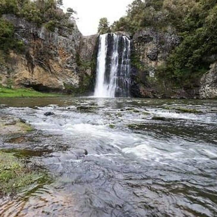
Hunua Falls
Standing at approximately 30 meters high, the beautiful Hunua Falls stem from headwaters in the Hunua Ranges and forms the Wairoa River as it makes its way ocean-ward to join the waters of the Hauraki Bay just above Clevedon, near Kauri Bay.
The Falls are able to be viewed from several angles, the easiest being a short 2-minute walk from the Falls Road Carpark. This track is a formed footpath and is suitable for all abilities and ages, and is pushchair friendly. Grab the perfect photo of the Falls using the oversized purpose-built photo frame on your way in!
Or enjoy the waterfall from a different angle on the Hunua Falls Loop Track also named the Falls Upper Lookout Walk. This short walk is clearly signposted from the Falls Road carpark and takes visitors up through the lush forest to a lookout point near the Falls. As the name suggests it is a loop track that continues on through the forest and back towards the base of the waterfall.
Another popular walking track at Hunua Falls is The Cossey – Massey Loop Track. At just on 3 hours, this 8.3 km walking track combines the Cossey’s Gorge Track and the Massey Track to make an enjoyable loop-walk through some of the stunning native forests of the Hunua Ranges.
How To Get To Hunua Falls
Heading south, the Hunua Falls are 40 minutes drive from the Auckland International Airport, and just over an hour’s drive from Auckland city. After departing the motorway at Papakura, drivers will need to head east to Hunua Road following it until the settlement of Hunua is reached.
Make a left just before the village onto White Road and then a right onto Falls Road, this will take you directly to the large Falls Road carpark. There are toilets and picnic facilities at the carpark as well as an information board.
The entrance to the park has an automatic gate which is open from 6 am to 9 pm across the summer months (October to March) and 6 am to 7 pm in winter. There are no public transport options for getting to Hunua Falls.
Where To Stay At Hunua Falls
There are some basic camping facilities provided within the Hunua Ranges Regional Park, and Certified Self-Contained vehicles may stay overnight in the Falls Road carpark (Fees will apply and bookings are required).
Boutique Bed and Breakfast style accommodation can also be found in the neighboring farmland with the following options within an easy 15-minute drive.
Walking Tracks In The Hunua Ranges
As well as the walking tracks around the Hunua Falls there are many more hiking and tramping options in the Hunua Ranges. For more information on where to go in the Hunua Ranges see here, or take a look below for our top picks.
Wairoa Loop Track
With its entry point off Moumoukai Road, the Wairoa Loop Track takes a fairly steep path up from the south side of the Wairoa picnic site. Walkers can look forward to superb views of the Wairoa Reservoir from the lookout platform, approximately 1.5 km from the entrance.
This walk takes approximately 3 hours, covering a distance of 6.2 km, and is suitable for people with a reasonable level of fitness.
Suspension Bridge Track
Those who wish can join the Suspension Bridge Track by parking at the Hunua Falls Carpark and walking the beginning of the Wairoa-Cossey Track or there is closer vehicle access from the carpark on the Wairoa Reservoir Access Road.
This walk covers a distance of 3.5 km (without the partial inclusion of the Wairoa-Cossey Track) and takes approximately 1.5 hrs to complete the loop. It is suitable for people with a reasonable level of fitness.
Ernies Track
Parking for Ernie’s Track is available at the Upper Mangatawhiri parking area and campground, however, the entry point is off Waterline Road (approximately 3 km away). Ernies Track follows the western edge of the Mangatawhiri Dam, providing great views, some challenging terrain, and the opportunity to cross the Mangatawhiri River.
This walk takes 4 hours and covers 6.2 km (not including the 3km from the carpark). It is only suitable for experienced hikers who are well equipped. The walk ends at Piggotts Campground which is just off Lilburne Road. It is possible to walk back to your vehicle via Lilburne Road (roughly a 6-7 km walk back to the Upper Mangatawhiri parking area and campground).
Rata Ridge Track
This is a great one to combine with Ernies Track as they both meet at the Piggotts Campsite. The Rata Ridge Track descends through the native forest towards the head of the Mangatangi Dam and then ends back up at the campsite.
At just on 2 hours it’s the perfect add-on to Ernies Track, particularly if camping at the Piggotts Campsite for the night. This track is suitable for people with a reasonable level of fitness.
Mountain Biking Trails in The Hunua Ranges
For more information on mountain biking tracks in the Hunua Ranges Regional Park see here or take a look below for our top 3 picks.
Mangatawhiri Challenge Track
Depending on personal fitness and ability the Mangatawhiri Challenge Track will take around 2 hours. The 15 km long run offers an undulating ridge ride above both the Mangatäwhiri and Wairoa reservoirs.
Parts of the Mangatawhiri Challenge trail are on public roads. This track is pretty steep and rough in places and only suitable for advanced riders.
Moumoukai Farm Track
A medium-grade mountain biking trail, the Moumoukai Farm Track takes approximately 1 hour 45 minutes to complete. Ride through areas of regenerating Kanuka and across several streams as you make your way around the 15 km trail.
The Moumoukai Farm Track detours off the Valley Loop Track and is considered an intermediate-grade mountain biking trail.
Valley Loop Track
Covering a distance of 14 km the Valley Loop Track is a great trail for those seeking an easy grade, however, be aware parts of the trail are completed along metal roads. There are some great swimming spots along the route and plenty of places to stop for a break or a quick bite to eat.
Depending on skill level and ability the Valley Loop Track takes around 1.5 hours. There is a stream crossing to navigate and the Mangatawhiri car park is the best place to park your vehicle.
If you are looking for a great place to enjoy New Zealand’s great outdoors without having to travel far from Auckland then Hunua Falls and the Hunua Ranges are the places to be.


